Size: a a a

OSM UA (OpenStreetMap Ukraine)

2019 May 29

N

Nykodym in OSM UA (OpenStreetMap Ukraine)
Публічна кадастрова карта знову додала OSM у вигляді підложки вже як НЕ тестовий шар. Адмін межі з АРК вже коректні, назви населених пунктів також українською там.
Єдине досі посилання на OSM немає.
источник

A

Andriy in OSM UA (OpenStreetMap Ukraine)
Багато де використовується OSM, посилання не пишуть
источник

n

ndygol in OSM UA (OpenStreetMap Ukraine)
Andriy
@ndygol Друкарська помилка перекладу в JOSM "теїування"
Дякую за повідомлення.
Виправив - https://translations.launchpad.net/josm/trunk/+pots/josm/uk/1181/+translate

Чекаємо на оновлення JOSM з оновленим перекладом
источник

n

ndygol in OSM UA (OpenStreetMap Ukraine)
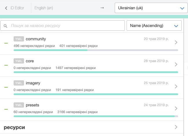
Так само, якщо ви знайшли помилку, неточність в перекладі iD – можете повідомити мені, або самотужки її виправити тут - https://www.transifex.com/openstreetmap/id-editor/translate/#uk
источник

n

ndygol in OSM UA (OpenStreetMap Ukraine)
Стан завершеності перекладу iD на поточний момент
источник

S

SV in OSM UA (OpenStreetMap Ukraine)
нарешті відповів хлопцю
источник

S

SV in OSM UA (OpenStreetMap Ukraine)
Hi Kilkenni,

   You authored a tagging proposal last year about supporting complex disputed boundaries in OpenStreetMap so I’m reaching out to you now as I’ve started to tag more disputed administrative boundary lines in OpenStreetMap. (1)
   The tags I’m using are disputed=yes (but I will leave the existing dispute=yes alone), adding disputed_by=* on disputed ways, and adding claimed_by=* on their relations to support multiple points-of-view.
   This is compatible with existing data, and a subset of the more complicated tagging proposals made on the tagging list in December of last year. That looks good to me, too… but I wanted to start somewhere and turns out most the data doesn’t even have the basic tags yet.
   I posted a diary entry about this sprint here: https://www.openstreetmap.org/user/nvk/diary/47890
   So far I’ve limited editing to existing features (like in Kashmir, Crimea, Western Sahara), but there actually aren’t that may so I may start adding missing ones later this month.
   If you have any questions please let me know, and if you want to help out let’s coordinate :)

   Cheers,
   _Nathaniel

   (1) Some authors don’t have easily identifiable email addresses, so I’ve sent them 1:1 messages on OSM directly.
источник

S

SV in OSM UA (OpenStreetMap Ukraine)
Sorry to reach you so late, I’m slightly busy on my side. The question is… controversial, to say the least.
On one hand, providing a set of borders “tuned” to the specific view of a certain country is beneficial for a project. Theoretically, it allows OSM to be used in these countries, as well as provides a way to show, as you’ve put it, ‘several points of view’ and somewhat tone down possible conflicts.
On the other hand, this whole idea smells bad for my taste. The whole issue is complex as, unlike most OSM objects, national borders cannot be based solely on ground truth, they involve sociology, legal system and politics (and most communities, OSM included, tend to evade politics at all costs like wildfire). Below I’ll try to explain my views on the matter, mostly drawn from Russia/Ukraine experience since I know the details.

1.    For me, drawing several borders because of ‘points of view’ is uncomfortably close to issuing a separate globe of flat Earth for people who, in spite of all scientific data, still believe that.

2.    Mapping zones with ‘frozen conflicts’ comes close to drawing conflicts in general, and as far as I understand, that’s something OSM tries to steer away from. Correct me if I’m wrong, I’m no expert on the matter. I have no idea how are Syria, Afghanistan or regions around Israel mapped border-wise but I see lots of military zones there. Does Syria in OSM show Turkish or Iranian occupation zone, or territories still held by rebels? That’s not a rhetorical question.

3.    OSM tends to follow the policy of ‘questionable information is better than no information’, eliminating white zones from the globe. I value information as much as the next guy, but I also understand that information not only describes the world but also influences the world back, influences the people. Russia tends to use this information to destroy, enlist ‘volunteers’ to fight at warzones (including our warzone) and bend countries with free information exchange (read: democratic countries) to her will. Providing balanced views of both the raper and the raped isn’t what I call ‘fair information representation’, but that’s not the worst point. What I’m trying to say is, trying to give a warmonger ground for talking feeds the flame of war. Make no mistake, they already use OSM in their hybrid war efforts and will continue to do so. That’s the point where editing information on the map starts taking its toll in human lives, even if indirectly. Since I tend to avoid such mapping myself for reasons described above I wonder how other mappers cope with responsibility issues.

Lack of information on the map in a bad thing. It is a situation where there is no good solution, only bad and worse. Mapping several borders tailored to tastes of different people is obviously not the most truthful solution but seems to be the easiest to implement in terms of public support (or, rather, public resistance). Still, I would not give it much hope in terms of protecting OSM from being banned in certain legislatures (or from edit wars). It is a half-measure with all the effects that go with it. My experience tells me authoritarian regimes treat gestures of good will as an invitation to push harder. If you’re interested in examples, Rutracker, a Russian torrent tracker, based its policy on full cooperation with authorities to avoid being banned. It was banned several years later, so this solution effectively postponed the sentence, not prevented it (and caused moral compromises and bad PR, obviously).

– Kilkenni
источник

S

SV in OSM UA (OpenStreetMap Ukraine)
можна публіканути в ОСМ:ЮА блозі/на ФБ, якщо цікаво.
источник

m

mike140 in OSM UA (OpenStreetMap Ukraine)
algot
При выборе Mapnik кидает 403 ошибку
Там ошибка в параметрах карты. Следующий архив нужно распаковать с заменой по указанному пути и будет прогружать мапник
источник

m

mike140 in OSM UA (OpenStreetMap Ukraine)
источник

a

algot in OSM UA (OpenStreetMap Ukraine)
@mike140 спасибо
источник

n

ndygol in OSM UA (OpenStreetMap Ukraine)
SV
можна публіканути в ОСМ:ЮА блозі/на ФБ, якщо цікаво.
прочитав. як на мене гарна відповідь. А є українська версія?
источник

S

SV in OSM UA (OpenStreetMap Ukraine)
ndygol
прочитав. як на мене гарна відповідь. А є українська версія?
ні, немає. Принаймні, поки що.
источник

n

ndygol in OSM UA (OpenStreetMap Ukraine)
Сьогодні день військового топографа
источник

V

Vova in OSM UA (OpenStreetMap Ukraine)
ну тогда поздравление коллегам с коцюбинского:)
источник

S

Sergey in OSM UA (OpenStreetMap Ukraine)
Цікаво, вони OSM також використовували?
https://www.facebook.com/1407079499591509/posts/2092296744403111/

Судячи з опису, більшу частину тієї карти можна побудувати на основі аналізу OSM-карти і зробити її динамічною.
источник
2019 May 30

n

ndygol in OSM UA (OpenStreetMap Ukraine)
источник

n

ndygol in OSM UA (OpenStreetMap Ukraine)
источник

n

ndygol in OSM UA (OpenStreetMap Ukraine)
источник